Basics of Map Coordinate Systems
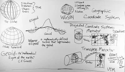
Geoid: C.F. Gauss, who first described it, called it the “mathematical figure of the Earth”. It is a smooth but highly irregular surface that can be derived only through extensive gravitational measurements and calculations. This gravity-defined equipotential surface theoretically would coincide with the mean ocean surface of the Earth, if the oceans and atmosphere were in equilibrium, at rest relative to the rotating Earth, and the seas extended through the continents (such as with a series of very narrow canals). The geoid is a much closer approximation of the true shape of the Earth than any reference ellipsoid could provide.
Reference Ellipsoid: A mathematically-defined surface that approximates the geoid. Because it is an idealized model of relative simplicity,reference ellipsoids are used as a preferred surface on which geodetic network computations are performed and point coordinates such as latitude, longitude and elevation are defined.
Datum: A datum is needed to be able to match coordinates on the reference surface to points on the physical surface of the Earth. It contains the specific definition of the reference surface as well as the point of origin and directions from that origin in order to specify the orientation of the surface.
Map Projection: A systematic transformation of a coordinate system defined on a three-dimensional reference surface such as a sphere or ellipsoid into coordinate locations on a two-dimensional plane. A projection provides the transformation between a geographic coordinate system and a flat, planar projected coordinate system, the kind found on maps.
WGS 84: The latest revision of the World Geodetic System, a standard for use in cartography, geodesy and navigation. It is made up of a standard coordinate system for the Earth, a standard reference ellipsoid with datum. The geoid serves to define the nominal sea level. The coordinates used are latitude and longitude on the surface of the ellipsoid, and a height or Z value which defines the vertical displacement above or below the geoid.
UTM: A standard coordinate system which divides the Earth between 80 degrees South and 84 degrees North latitude into sixty zones, each six-degrees of longitude wide. It uses a transverse Mercator projection and, unlike WGS 84, is a 2-dimensional Cartesian system that specifies locations on the earth in terms of East and North coordinates independent of any vertical position.


Comments
Post a Comment